AddUrlYahoo

Lapindo mud resulted in Buildings Fracture

Selasa, 22 Juni 2010

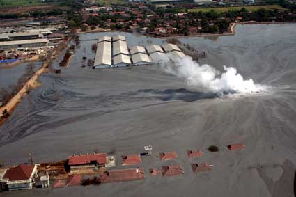
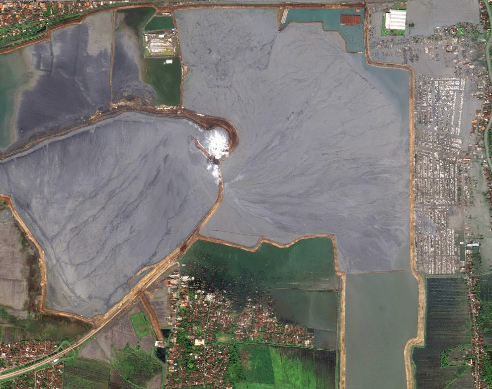
SURABAYA, KOMPAS.com - Feasibility Study Team Results indicate settlement, the land around the center of the Lapindo mudflow at a radius of 1.5 kilometers decreased. Meanwhile, land in the West Village and Jatirejo Siring actually rose to 30 centimeters. Changes in soil structure resulted in settlements and buildings around the cracks.
Because the land around the pond reservoirs vanish, then the soil is also automatically appear on the other side goes up due to pressure.

Feasibility Study of Settlements Team Leader (TKKP) Professor Nyoman Sutantra from Surabaya Institute of Technology, said lower surface of the soil at a radius of 1.5 kilometers around the center of the mudflow caused by the pressure load in the pond mud shelters. Expense is what finally hit the ground around the blast center, so the surface soil decreased along with the emergence of bubbles of gas mixed with mud.

Since November 2009, TKKP recorded average decline in soil around the pond mud Lapindo reached 10 centimeters per month. Therefore, within six months recorded a drop in soil up to 60 inches with the highest point in the segment decreased Porong Highway. "Because the land around the pond reservoirs vanish, then the soil is also automatically appear on the other side goes up due to pressure. Land which rose about 30 feet we found in the western and north western and Jatirejo Siring Village," said Professor Nyoman Sutantra, Wednesday (19 / 5 / 2010) in Surabaya.

Due to this condition, now housing residents and buildings in 13 villages and sub Porong Tanggulangin not fit to live because of the cracks. Some areas, including West Siring, Jatirejo, Mindi, Pamotan, Ketapang, Besuki, and Gempolsari.

According to Professor Nyoman Sutantra, TKKP still continue to examine the feasibility of a number of settlements in the two districts. Eligibility criteria is measured from the level of soil degradation, the concentration of flammable methane in the gas bubbles that appear, water conditions, and the threat of breakdown dike mudguard. "In two to three weeks ahead TKKP will formulate recommendations which were then forwarded to the Governor of East Java. If indeed the settlement residents and the environment really do not feasible, then the residents should be evacuated," he said.
READ MORE - Lapindo mud resulted in Buildings Fracture

Lumpur Lapindo Victims File 61,763 Outstanding

SIDOARJO, KOMPAS.com - A total of 61,763 victims file PT Lapindo Brantas Inc. mud in Sidoarjo, not to be compensated by PT Lapindo Jaya Minarak (MLJ) as the paymaster of PT Lapindo.

"We have 75,000 files that have been paid from the total of 13,237 files that come in," said Vice President of PT Lapindo Jaya Minarak, Andi Darussalam Tabusala after attending a visit by President Susilo Bambang Yudhoyono (SBY) at point 25 Sidoarjo, Monday (29 / 3 / 2010).

Andi admits, PT MLJ not settle the payment for 42 percent of the files that have been verified. In addition, there is evidence of land and asset ownership has not been verified.

According to Andi, the file verification process should be done in two stages. First Sidoarjo Mud Disaster Agency (BPLS) and the second by PT MLJ. "According to the target, the completion of the mud victims compensation paid will be completed in 2012," he promised.

He argues, it's still in complete compensation by way of pay in installments amounting to USD 15 million every month. "Money damages are already transferred to the account of the early victims of the mud on every month," he explained.

He also admitted, some time ago there was a delay in payment. That, he said, because of the company's financial problems now being experienced by Minarak. "But, at this time we promise to complete the payment in a timely manner, so that could be completed in accordance with the target," he said.
READ MORE - Lumpur Lapindo Victims File 61,763 Outstanding

Lapindo Poisons Four Years Together

Beginning in January 2010 the gas bubbles began to burst from the home page of Ershad. The former farmer from East Besuki horrified.

He is very worried because this gas burning when the fire ignited. Despite lasting only a few days, these events can indicate how he and residents of East Besuki, Ketapang, Mindi, Jatirejo West, West Siring, Gedang, and villages around a central burst of life is not safe. For four years, no fewer than 180 bursts and bubbles of gas are found. His condition is left, some are handled, the rest marked only board that said dangerous.

Emission of hydrocarbon gas on the bubble bursts and found in West Siring, West Jatirejo, and Mindi reached 441 200 ppm, eighty times as much on the threshold of the standard which is only 5000 ppm (Decree of the Minister of Environment No. 129 of 2003). The limit on the ambient air exceeded 0.24 ppm by identifying up to 55 000 ppm, which means that 229 100 times the threshold standard. The findings of the team monitoring the formation of settlements in East Java in 2008 the Governor was followed up with letters of recommendation to the President.

What is immoral, the President issued Presidential Regulation No. 48/2008 which refers precisely stated as a priority area affected. New year 2009 issued Presidential Regulation No. 40/2009 which regulates the evacuation through social assistance for residents in the area of West Siring, West Jatirejo, and Mindi (three RT).

By letting the condition since the sludge spraying on May 29, 2006, not surprisingly, found an increasing number of patients with acute respiratory infection in Porong. Based on data of local health centers, patients with ARI in 2007 recorded 46 652 people, has doubled from the year 2006 which is only about 23,000. Poor water quality also shows the impact of increase in female patients with reproductive health disorders. This trend in 2008 was recorded on postal services; health Jabon that ever existed in the territory of the former Toll Besuki evacuation.

Hazards of heavy metal

Findings Forum for Environment (WALHI), East Java through research content of heavy metals and polycyclic aromatic hydrocarbons (PAHs) also showed Exceeding the threshold of eligibility. Type of heavy metal cadmium (Cd), and lead (Pb) were found to exceed the standard at all 20 sample points in 2007/2008 with a total average of more than 0.3063 milligrams per liter (mg / l), or 100 times more on top threshold quality standards established by the Minister of Health Decree No 907/2002 which is only 0.003 mg / l. The content of chromium (Cr) and copper (Cu) is still below the threshold standard.

PAHs are also found in type crysene exceeded standard in almost all sample points in the area of mud and the surrounding region, while Ben (z) anthracene was found in three sample points. PAHs are organic compounds that are dangerous and carcinogenic. Did not cause the formation of tumors or cancer directly, but in the body's metabolism system will be changed into dihydrodiol epoxides alkylating compounds very reactive and very potentially giving rise to tumors and cancer risk (UNEP, 2001). The impact also can not be seen immediately. It will take five to 10 years to discover the potential of lung cancer, skin cancer, and bladder cancer for men who never exposed in more than eight hours.

Maternal Mortality Jumi, Tiyami, Luluk, Sutrisno, Jacob, and several other residents in the period 2008-2009 with an undiagnosed cause should be the record clearly important for the government apparatus to perform specific actions and monitor intensively. Mother Jumi enlarged stomach after a year of the mudflow, the next year he died.

Origin of mud from a depth of more than 9,000 feet can also lead to all kinds of suspicious mineral content and various other dangerous substances. The discovery of heavy metals, various types of hydrocarbons, and PAH do not close the possibility still can be found types of radioactive compounds that have a more significant impact.

Sludge treatment before flushed into the sea via the River Porong should also be undertaken. If not, the whole region will be contaminated with Madura Strait (WALHI, 2006). Moreover, relying ponds of fresh water supply from river and sea water Porong Madura Strait. The largest organic shrimp production from the eastern region of Sidoarjo, with export value of approximately USD 800 billion per year, also could not have maintained the number and quality.

Milkfish yields that have declined in the ponds in and around Permisan not normally a strong indication of water quality. Can be imagined, if the content of heavy metals and other dangerous substances is continuously accumulating in biota consumed, then the impact of the Lapindo mud will be increasingly widespread.

Damage and loss of living space assets for settlement residents who only assessed the extent of land and building materials is an insult logic. Ershad's rice fields as production land that can not be processed since the first blast was just one of a few tens of thousands of area residents affected by the mud. Approximately 80 hectares of rice fields had ever submerged mud in the village of Besuki leaving no requirement for rice growing. Ershad and the other farmers had once tried. Although rice grows life, there is no grain of rice produced. The government and the company just the same money to see the impact of sludge-related only physical damage there. Ershad and thousands of other citizens who do not fit within the map area affected by March 22, 2007 was never viewed as victims.

Urgent action

Poisons and dangerous content certainly can not be solved with the bulletin board signs of danger. Ecological destruction Porong River estuary region, eastern coastal Sidoarjo and Madura Strait also can not be conjured up by doing physical development along the river banks. Moreover, the dangers and risks covered by Lapindo mud tourism program that was launched or magic by doing physical development along the river banks.

The allocation of public money to $ 7.210 trillion until 2014 in the Medium Term Development Plan of Action for Lapindo mudflow handling is never enough when calculating the effects of a complex and widespread. Response and recovery are done only for the actual imaging.

Action to find out hazardous substances, the recovery of environmental quality, medical examination, social and economic recovery should be done without waiting for the citizens of poorer conditions. Evacuation of residents and traffic restrictions on dangerous territory in the vicinity of the mudflow and gas has to be conducted.

by Bambang Catur Nusantara - Executive Director Indonesian Forum for Environment (WALHI), East Java
READ MORE - Lapindo Poisons Four Years Together

Mud tourism Prepared USD 273 Billion


SURABAYA, KOMPAS.com - The government has set aside at least Rp 273 billion for realization of geological tourism development around the hot mudflow PT Lapindo Brantas Inc., Sidoarjo.

"The government through the Ministry of Maritime Affairs and Fisheries has set aside Rp 273 billion for geological tour of Lapindo," said Governor of East Java, Soekarwo in Surabaya on Friday (05/28/2010).

According to him, the location of geological tourist attraction is located on the north side of PT Lapindo hot mudflow. "The location has been visited by President Yudhoyono some time ago," he said.

Meanwhile, the land that would become a tourist attraction is approximately 83 hectares of geology and not far from the northern coastal area of Sidoarjo.

"Year 2011 DED (detailed engineering design / technical planning) is out. The possibility of that year the project is doable," said the Governor.

Amblasnya associated with more land around the Lapindo mudflow, he considered not a problem to worry about.

"Subsidence (sinkhole) that can be handled provided that no additional dike because during the emergence of new bursts of spray-and dike subsidence due to the many new additions to become its own expense," he said quoting the explanation of geologists from the Institute of Technology (ITS) and the University of Airlangga (Airlangga University).

According to the governor, this time point the mud flow has reached 180,000, including a new spray which amount is estimated at 30,000 to 50,000.
READ MORE - Mud tourism Prepared USD 273 Billion

Tourists curious about the Lapindo mud

SURABAYA, KOMPAS - Lapindo mudflow in Sidoarjo, East Java, which apparently led to increasingly apprehensive curiosity for tourists in the country and abroad.
Most domestic and foreign tourists who stop in Surabaya always took to visit the mud in Sidoarjo. "Although not promoted, every tourist who visited Singapore would want to see the phenomenon of mud flow. They were curious," said Chairman of the Association of Indonesian Travel Haryono Gondhosoewito in Surabaya in East Java, on Tuesday (06/01/2010).
However, until now the road leading to Sidoarjo is still hampered by damage to the arterial road and Porong-Gempol toll due to mud flow.
According to Haryono, road damage at this point is very disturbing tourism in East Java. "If the streets of Surabaya-Malang, especially for the links Porong smoothly, increasing tourist flows and the economy will be very significant. But if it be left like that, the potential economic losses are higher in East Java," said Haryono.
READ MORE - Tourists curious about the Lapindo mud

Railroad-Porong Tanggulangin Sinkhole

Senin, 21 Juni 2010

Surabaya (ANTARA) - Rail train at the route segment Tanggulangin-Porong, Sidoarjo, East Java, about two centimeters sinkhole caused by a new burst of hot mud PT Lapindo Brantas.
"We get information on the rail trail sinkhole until it reaches two inches. However, until now not been up to disrupt rail travel, "said Public Relations of Railway Operation Region VIII / Surabaya, Chess Herry Winarno, Wednesday.
Over the incident, the Regional Operations (DAOP) VIII formed a task force to anticipate the reduction amblesnya railway embankment which is on the hot mudguard.
The task force was strengthened 20 personnel and will be divided into three groups to control the condition of the tracks in Porong.
They will also be in charge of patching and propping rail sinkhole with material that has long been groomed in Sidoarjo Station.
In connection with the incident, DAOP VIII since 19 April has been declared the status of II-B, which reminds the driver to run trains with a maximum speed of 10 kilometers per hour. In normal circumstances this route can be crossed by train with an average speed of 40-60 kilometers per hour.
If the situation continues to deteriorate, it increased again, to the status II-C, the maximum train speed is only five kilometers per hour.
In addition, Herry also reminded passengers not to smoke when the train crossed the line. "To the train driver was not carrying fuel for braking at the track because it is dangerous," he said.
Typically, a series of train consists of 20-22 fuel tank car fuel. When braking suddenly could cause a spark caused by friction between wheel and rail.

READ MORE - Railroad-Porong Tanggulangin Sinkhole

Ballooned road on the highway Porong

Minggu, 20 Juni 2010

A highway segment in Sidoarjo, ballooned to a height of 50 centimeters. Roads caused by the urge bloated small-scale gas (bubble) below the surface of the earth, associated with the Lapindo mudflow in its east side.

Bubble unpaved soil layer resulted in there sticking out like a pregnant belly, and even led to cracks in diameter 1.5 meters x 1.5 meters.

The incident took place in Malang road directions, exactly in front of the monument yellow Siring Village, Porong.

According to the Sidoarjo Mud Disaster Agency (BPLS), is prone to bursts of fire burn if ignited.

"The condition of the mound on the east side, it's been a bit deflated" said Head of Public Relations BPLS, Ahmad Zulkarnain.

He said, bursts of methane gas that they contain flammable. Uncategorized low gas explosive limit (Lel). If ignited the fire, near the blast area could be burned. Nevertheless, the existing conditions otherwise still not safe enough because it may cause an explosion.

"If it did not explode. But can burn if ignited a fire, "said Zulkarnain. These bursts arise due to strong pressure from the surface through the gas underground.

Siring Village area, said Zulkarnain, has been declared unfit for human habitation into geology or natural zone of ground deformation is damaged. One characteristic of this zone is often the emergence of small bursts.

The appearance of bursts in Porong highway agencies in two days to go down as bursts of-160 in over three years. During that time, similar bursts has also appeared in the village of Mindi, Siring, Jatirejo until Ketapang village.

In order to handle the incident, BPLS has localizes bursts so as not to pass that road users across the highway Porong. In addition to police band fitted line (police line) is yellow, a number of signs posted around the roadblock area around the emergence of the blast. "We still need to observe two to three days for subsequent handling by alerting the monitoring officer there," he said.

Visible Then PPA Ahrie Sidoarjo district police Sonta Nasution said, still be allowed vehicle flow through Porong highway. The reason, it was not dangerous to vehicles and road users, so that traffic flow should not be transferred from there.

"However, we remain deployed personnel near the crack path to anticipate every possibility that might happen," said Ahrie when checking the condition of these cracks Porong highway.

Meanwhile, disaster management experts from Ten November Institute of Technology (ITS) Surabaya, said Amin Widodo, the mound of dirt on the highway Porong to beware. Section, the phenomenon indicates the occurrence of ground movement beneath the road surface was due to be dragged by the center of the mudflow.

Amin compares the geological phenomenon around the center of the mudflow as a funnel. That is, the position of the ground at the top who have a rift, forming broad, but more and more narrowed down the width. That happened because the existing ground surface above will be drawn into all up through the center of mud and gas.

In such conditions, the gas can be peeking out from the cracked soil. If ignited the fire, flames would be dangerous. "Especially if the point of the cracks is still a lot of highway vehicle passed," he explained.

For that, the professor who is also member of the Centre for Disaster Studies of ITS was asked BPLS, police, Public Works Department, and other related officials actually did anticipate that the bubble in Porong highway does not endanger the public. For example, with the lid off the flow of vehicles passing on the highway which is cracked, or stop and disinfect the area so as not to pass the vehicle.

"To ensure the anticipation of what must be done, cracks around the point on the highway must be installed to monitor instrument (pressure) gas, whether high or not," he explained.

It was considered important because of the phenomenon, Amin said, would last long. Especially today, the center of a large mudflow that there were three points, and around the three point boost is also new cracks appear.
READ MORE - Ballooned road on the highway Porong

Monitoring Land Subsidence in the Lapindo mudflow Porong with GPS

Senin, 14 Juni 2010

HEAT IN THE MUD SHOWER Porong SIDOARJO

Hot mud flow from beneath the earth's surface to the top surface of the earth had happened in Sidoarjo, East Java Porong area (Approximately 20 kilometers south of Surabaya). These bursts occur when the PT Lapindo to explore gas and oil with drilling in areas such Porong. Mechanization of this incident are still contradictory between human neglect and natural phenomena. As a result of continuous mudflow with large volume has caused the flood and mud puddles in the vicinity of Porong. Recorded until now several villages have drowned in the mud. Until when mudflow will occur is still a question mark.

PHENOMENON land subsidence in Porong SIDOARJO

Land subsidence is defined as land subsidence as a function of time caused by many factors, such as excessive intake of ground water (groundwater over-exploitation), the release of a massive gas and mud from the ground to the surface, decreasing the burden of building, the reduction due to consolidation nature of the layers of soil, and the decrease due to tectonic forces. Land subsidence or decrease in the detection of land has occurred in Porong Sidoarjo. As is known in the area of Porong Sidoarjo, precisely in the areas of oil and gas exploration managed by PT Lapindo, there has been a hot mudflow from below the surface with a large volume and has continued until today. Effect of discharge gas and mud, as described above has implications for the occurrence of land subsidence

IMPACT that accompany the occurrence of land subsidence

Land subsidence can cause damage to buildings and structures such as cracks and amblasan, reversal of direction of drainage systems (canal waterways), and increases the likelihood of catastrophic floods (Poland and Davis, 1969). Even the effects of subsidence can cause damage to more extreme form of land subsidence (sinkholes) produced a large hole, and a large longitudinal fractures (Fisurries) in several places around the area of land subsidence occurred. The effect of land subsidence is usually not felt in the short term, but in some cases may occur in a faster time.

Examples of the impact of land subsidence caused cracks in buildings and structures we can see disebagian Greater Jakarta and Bandung, which is based on research results is an area experiencing land subsidence resulting from excessive ground water sampling. Meanwhile, sinkholes and Fisurries example we can see each occurred in the United States, and also in China.

Seeing the negative impact caused by the effects of land subsidence in the form of building damage, possibly even fatalities amblasan big event, then the monitoring of land subsidence needs to be done, it is even possible to reduce the rate of occurrence of land subsidence with a special effort.

MONITORING TECHNIQUE land subsidence

In principle, the decline in soil or land subsidence of an area can be monitored using several methods, both hydrogeological methods (eg ground water level observation and observation with an inverted ekstensometer and piezometer into the quantity decrease of ground water) and method of geotechnical, as well as methods geodetic survey methods, such as carpenter's level (leveling), micro-gravity survey, surveys, GPS (Global Positioning System), and InSAR (interferometric Synthetic Aperture Radar).

MONITORING TECHNIQUE land subsidence in Porong SIDOARJO WITH GPS

GPS is a satellite navigation system and positioning system based on observations of satellite-satellite Global Positioning System [Abidin, 2000; Hofmann-Wellenhof et al., 1997]. Study principles penurunah ground GPS survey method is by placing some point watched on a few selected locations, periodically or continuously to determine the precise coordinates using GPS survey methods. By studying the pattern and speed of change in the coordinates of the points from the survey that one to the next survey or the results of continuous data, the characteristics of soil degradation (land subsidence) will be calculated and studied further.

The image below is a GPS receiver device that is placed in several points of observation. The dots represent the decrease in the ground because these points were located in areas that allegedly decreased soil.

GPS provides value vector of ground motion in three dimensions (two horizontal components and one vertical component). So in addition to providing information about the amount of land subsidence, as well as GPS also provides information on ground motion in the horizontal direction.

GPS provides vector movement and decrease the value of land in a single reference coordinate system. With that the GPS can be used to monitor the movement of a regional territory effectively and efficiently.

GPS can provide movement vector value with the level of precision to a few mm, with high consistency, both spatial and temporal. With a high level of precision and consistency of the expected magnitude of movement and a small decrease in soil can be detected with good will.

GPS can be used continuously without depending on the time (day or night), in all weather conditions. With these characteristics, the implementation of GPS surveys for monitoring the movement and land subsidence can be performed effectively and flexibly.

As already mentioned above that the decline in land (land subsidence) has been detected occurred around Porong hot mudflow in Sidoarjo. With a view to seeing further land subsidence characteristics in Porong Sidoarjo, PT Lapindo Brantas, together with the Scientific Group of the IAG and Geodesy Faculty of Civil and Environmental Engineering, ITB has conducted a GPS survey. The results showed GPS has detected a decrease in soil at decimetre level within less than one month around Porong Sidoarjo.

To continue to monitor land subsidence is still happening in Porong Sidoarjo, PT Lapindo Brantas and PT LAPI ITB which is represented by the Scientific Group of the Scientific Group of Geodesy and Earth Sciences have agreed to continue cooperation in the monitoring of land subsidence which was previously dlakukan PT Lapindo Brantas, together with the IAG and Expertise Group ITB Central Library. The main agreement is entered into the GPS measurements are episodic and continuous in the vicinity of Porong Sidoarjo. Realizations, for episodic GPS observations carried out per month, and the number of measured points is about ten to seventeen points. Total episodic GPS observations that have been done is from June to October 2006 (5 kala). Meanwhile, continuous GPS installed in Porong starting from the end of september until now.

Results of the study is complete GPS has detected a decline in value of land subsidence at decimetre level within less than one month and sub-meter level within less than two months. (IAG-Geodesy Research Group, 2006; PT LAPI, 2006). then within a period of five months, soil degradation that occurred in Porong Sidoarjo already in level meters. Meanwhile the results of continuous monitoring of land subsidence using GPS to show which continues even today.

The result of soil degradation that occurred in Porong showed substantial decrease in speed and also with a relatively faster speed compared with the usual decline in other areas (area of Bandung and Jakarta experienced a decrease of land with speed 10 cm / year).

(Kelompok Keilmuan GEODESI - Fakultas Ilmu dan Teknologi Kebumian, ITB Bandung)


READ MORE - Monitoring Land Subsidence in the Lapindo mudflow Porong with GPS

DAMAGES RESULTING of PORONG MUD VULCANO

Jumat, 04 Juni 2010


The Mud Volcano and its surrounding areas in Sidoarjo, east java (AFP/Konos Satellite image on May,2008)


The maintenance work on going near the caldera of the mud vulcano. (AFP)

READ MORE - DAMAGES RESULTING of PORONG MUD VULCANO

History of Porong Mud Volcano

On the four-year anniversary of its eruption, international scientists say they are almost certain a mud volcano that displaced tens of thousands of villagers in central Indonesia was caused by faulty drilling of a gas exploration well - not an earthquake as claimed by the gas company. "We are more certain than ever that the Lusi mud volcano is an unnatural disaster and was triggered by drilling" said Richard Davies, lead author of a study published this week in the academic journal Earth and Planetary Science Letters.
Two years ago now, on 28 May 2006, gas company PT Lapindo Brantas exploring for gas in Sidoarjo, in East Java, Indonesia, drilled a borehole. At 5 AM, a secondary stage of drilling began and the drill string went about 9,300 feet down, after which the first small eruption of water, steam and a small amount of gas occurred at a location just southwest of the well. Several other eruptions followed over the next few days. The flow of hot mud has not ceased since.

Fourteen people have been killed and 30,000 people have been evacuated from the area. At least a dozen villages, with more than 10,000 homes have been destroyed while schools, offices and factories have also been wiped out and a major impact on the wider marine and coastal environment is expected.
READ MORE - History of Porong Mud Volcano

Location

Kamis, 03 Juni 2010

The location of this mudflow in Porong, namely in the southern district of Sidoarjo regency, about 12 km south of the town of Sidoarjo. Districts borders the District of Gempol (Pasuruan) in the south.
Location bursts of only 150-500 meters away from the well of the Banjar Panji-1 (BJP-1), which is owned gas exploration wells as operator Lapindo Brantas Brantas block. Therefore, until recently, the hot mud flow was allegedly caused by drilling activities of Lapindo Brantas in the well. Lapindo Brantas own party have two theories about the origin of bursts. First, the mud flow associated with errors in the drilling procedure. Second, the mud flow coincides with a drilling accident caused by something unknown. But a lot of material that is more inclined incident was caused by drilling.
Location is a residential area and in surrounding areas is one of the main industrial area in East Java. Not far from the location there are bursts of Surabaya-Gempol toll roads, highways Surabaya-Malang-Pasuruan and Surabaya-Banyuwangi (lane east coast), and cross the railway line east of Surabaya-Malang and Surabaya-Banyuwangi, Indonesia
READ MORE - Location